If you’ve ever wanted to draw a map, this is the post for you. But please don’t go if you’ve never considered map-making! This is one of those things anyone can draw. Plus, it’s pretty therapeutic.
I’ve developed a strange obsession with cartography over the years and I thought I’d show you how I draw my maps, starting with the easy stuff. Of course, there are many different ways to do this. Probably cleaner ones too. I like the organic and not-so-perfect way of drawing a map, so most of this is freehand. If you don’t like that, feel free to use your ruler. 🙂
The map I’m sharing with you today is incomplete – I’m planning on spreading it over four or six pages, then framing them separately to hang on the wall. I’ll snap a pic for you when all of it is done. 🙂
I drew inspiration for this map from Roicester, the capital of Aelland, where The Physician’s Apprentice is set. Roicester isn’t drawn to perfect scale, like my world map is, but this is for personal use and won’t be included in any novel.
OK. Before you start, you’ll need a basic idea of how your city should look. Take some time to decide which important landmarks to include and where your most important roads should be. Study some aerial maps for ideas here. When I started mapping, I looked at many maps of ancient Europe, or those drawn by fantasy cartographers.
If you want to include your map in your novel, or the game you’re working on, scale becomes important, so consider that. It’s also a good idea to keep track of where north is, which roads will enter/exit your city and if nature will influence the city’s layout. For example, cities built next to rivers or mountains will follow the curve of the natural landmark. Few cities are built to rise with the mountain slope, most will remain in the valley below.
Roicester isn’t built near any major rivers, forests or mountains, so that simplifies my design.
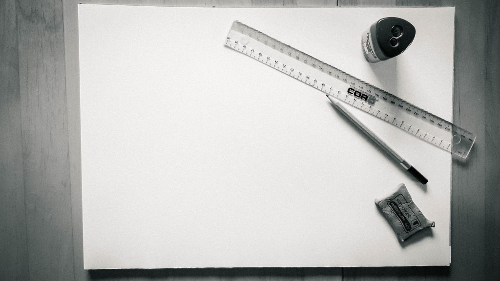
You’ll need paper and drawing supplies. If that’s not your cup of tea, go digital. I’ve also made some digital maps and will include examples at the end of the post.

The first thing to do is plot out where your major roads or rail will run. For Roicester, I wanted a simplified design. It’s a small, overcrowded city with highly functional railways, so I figured a few, straightforward main ways would be perfect.
I’m sorry the lines are so dull, I didn’t want to draw them too dark, since they’re only guides. I also drew them wider than the final design will be, so I have some room to change if needed.
The last thing I included is a tiny north-marker. It’s barely visible, but is in the upper-right corner.

Next, you want to place important structures and landmarks. Keep in mind that main roads or rail will often lead to these places, then include that in your layout.

Let the fun commence. Pick a place to start and draw small shapes with gaps between them. The gaps become streets and the shapes represent city blocks.
To shift the focus from blocks to streets, draw your shapes bigger, so the smaller roads fall away and the more important ones are emphasised (I did this with the two digital maps at the bottom of the post). On the flipside, you could go micro and draw in every individual house or building. Whatever floats your boat.
Try to keep your shapes organic, and keep track roads. You don’t want a city with the same square blocks and straight streets, because it becomes too monotonous (except, of course, if that’s exactly what you’re going for). Usually, real cities will be meticulous at the place of origin, with straighter streets and more defined blocks, but will continue to develop at random. This means strange dead ends, circles and parts that make no sense.
If you study maps of old Rome, versus how it looks today, you’ll see this idea in reality. Even where the city may have been planned out before, renovations and extras will change the original shape of a city. Plus, buildings will pop up around landmarks. Vendors will come and go near tourist attractions, but these parts will always be more crowded than the residential areas.

Keep going until you reach the fringe of your city. The edge should be irregular, real cities aren’t developed in a perfect shape. More people will remain close to the highways or railroads, while fewer will stay on the outskirts, especially farther from the roads. These will translate as country areas on your map.


From there on, it’s much of the same – which is why I said drawing a map is therapeutic. I’ve been working on this map for about five hours while watching TV, and this following picture shows my progress. This is an A3 size paper, by the way.

I added some fragments to the outskirts and shaded some of the blocks darker than others.


There’s nothing perfect about this map, but I think that’s what makes it more realistic. I like the hand-drawn quality. In fact, I can picture one of my characters, Lance, drawing this map in one of his lessons with Physician El-Amin. His fingers are dirty and his tongue pokes from the corner of his mouth, brow furrowed in concentration.
My digital maps are cleaner. As I mentioned earlier, the blocks are drawn much larger so the map represents the more important roads instead of little details.


Learn from my mistakes and pick a font that’s easier to read. 🙂 This one is all fancy-like, but nobody knows what the hell is written there. Again, look at other maps for inspiration.
And that’s all I have to say about maps, for now. 🙂
Thanks for stopping by.
Yolandie


Let’s Chat!